DroneView
Markets Served Pricing
Blog & News Contact
Geospatial Data Acquisition Geospatial Data Processing Geospatial Products
Company Leadership Team Certifications & Memberships Careers
Services Geospatial Data Acquisition Geospatial Data Processing Geospatial Products Markets ServedPricing
DroneView
Aerial Mapping and Geospatial Services
Blog & News About Company Leadership Team Certifications & Memberships Careers Contact
Featured
DVT 10th Year Anniversary.jpg
Mar 25, 2025
Celebrating Our 10th Anniversary – Thank You for Being a Part of Our Success
Mar 25, 2025
Mar 25, 2025
Large Area (83,200 Acres) Piloted Imagery and LiDAR Acquisition + Mapping
Feb 4, 2025
What do the distinct stages of acquisition for fixed wing, helicopter, and mobile LiDAR mapping projects look like?
Feb 4, 2025
Feb 4, 2025
Utility PLS CAD Mapping.jpg
Jan 21, 2025
LiDAR + Photogrammetry = the most high accuracy mapping products ever created - insights with Michael Crain
Jan 21, 2025
Jan 21, 2025
pls5.jpeg
Jan 7, 2025
The impact of LiDAR on accuracy and workflow management - insights from Prince Tetteh
Jan 7, 2025
Jan 7, 2025
DroneView More than Just Drones.jpg
Jan 6, 2025
DroneView Year in Review and 2025 Outlook
Jan 6, 2025
Jan 6, 2025
DroneView Technologies Empowers Aerial Data Solutions Through Trusted Partnerships - Insights from Jason Heywood
Dec 10, 2024
DroneView Technologies Empowers Aerial Data Solutions Through Trusted Partnerships - Insights from Jason Heywood
Dec 10, 2024

Jason Heywood works with clients to assess different mapping needs and define how DroneView's extensive network can support those requirements, highlighting how trust and understanding are essential elements of any geospatial data acquisition project.

Dec 10, 2024
DVT Jan 2023.jpg
Jan 4, 2023
DroneView Year in Review and 2023 Outlook
Jan 4, 2023

 DroneView completed another record year in 2022

Jan 4, 2023
Jun 7, 2022
DroneView Expands LiDAR and Photogrammetry Aerial Mapping Team
Jun 7, 2022

Connie Krampf, an ASPRS Certified Photogrammetrist with over 25 years of aerial mapping and geospatial experience has joined DroneView, expanding the LiDAR and Photogrammetry aerial mapping team

Jun 7, 2022
msps1.jpg
Feb 16, 2022
DroneView's Jason Heywood is presenting - High Accuracy Aerial Mapping at the Michigan Society of Professional Surveyors Conference
Feb 16, 2022

DroneView’s Jason Heywood is presenting High Accuracy Aerial Mapping at the Michigan Society of Professional Surveyors conference - Traverse City, MI Feb 16-18th

Feb 16, 2022
DroneView Aerial Mapping
Jan 5, 2022
DroneView: Year in Review and 2022 Outlook
Jan 5, 2022

DroneView has continued to steadily grow, setting records in 2020 and again in 2021. We doubled the number of active customers, maintained our existing clients and increased revenues by over 80% during this period.

Jan 5, 2022
DroneView expands LiDAR and Photogrammetry Aerial Mapping team
Oct 27, 2021
DroneView expands LiDAR and Photogrammetry Aerial Mapping team
Oct 27, 2021

DroneView expands LiDAR and Photogrammetry Aerial Mapping team - Lucas Wilsing has joined DroneView as a Director of Client Services. Lucas was previously with Keystone Aerial Surveys, a Vexcel company and Quantum Spatial, a NV5 company.

Oct 27, 2021
DroneView - Commercial UAV.png
Aug 18, 2021
Commercial UAV NEWS: Has the Evolution of the Commercial Drone Industry Created Opportunities or Cultivated Misconceptions?
Aug 18, 2021

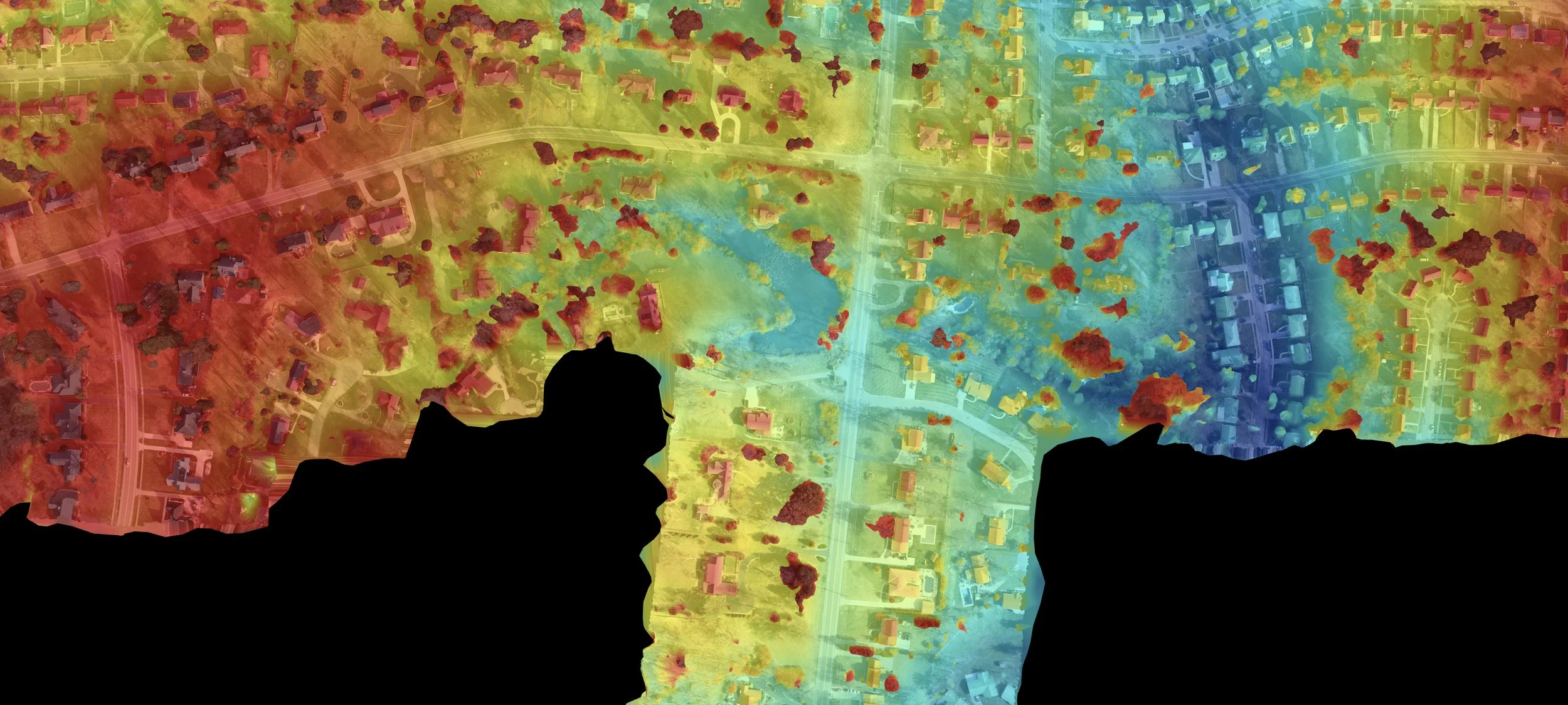
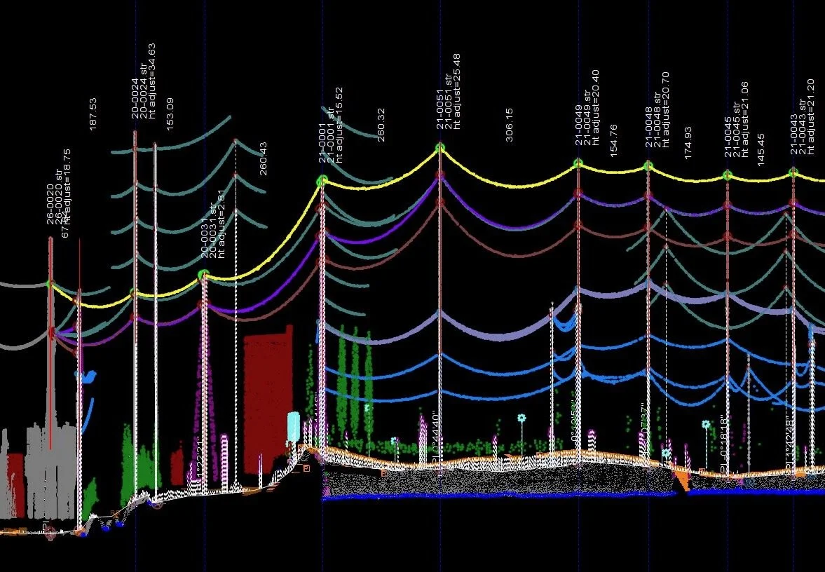
Despite the many great advances with drone technology and automated drone flight to date there is no ‘easy button’ when it comes to achieving high accuracy mapping products

Aug 18, 2021
photogrammetry_building.jpg
Mar 2, 2021
LiDAR + Photogrammetry Workflows
Mar 2, 2021

The combination of imagery and LIDAR changes this paradigm, but it all comes down to accuracy, because if it’s not accurate, it's worthless, no matter what the cost is.

Mar 2, 2021
Jason Heywood Promoted to President of DroneView Technologies
Feb 16, 2021
Jason Heywood Promoted to President of DroneView Technologies
Feb 16, 2021

Jason Heywood, a Certified Photogrammetrist, has been promoted to president of DroneView Technologies. Jason has spent the past 25 years in aerial mapping and geospatial services. Jason has helped to shape and build DroneView’s aerial mapping business. His extensive geospatial expertise has helped DroneView to win projects and serve clients throughout the United States

Feb 16, 2021
DroneView Year in Review and Outlook for 2021
Jan 5, 2021
DroneView Year in Review and Outlook for 2021
Jan 5, 2021
Jan 5, 2021
Michael Crain Joins DroneView Technologies as Director of Geospatial Services
Sep 17, 2020
Michael Crain Joins DroneView Technologies as Director of Geospatial Services
Sep 17, 2020
Sep 17, 2020
DroneView+Meeting.jpg
Jul 23, 2020
DroneView - Planning for the "New Normal"
Jul 23, 2020

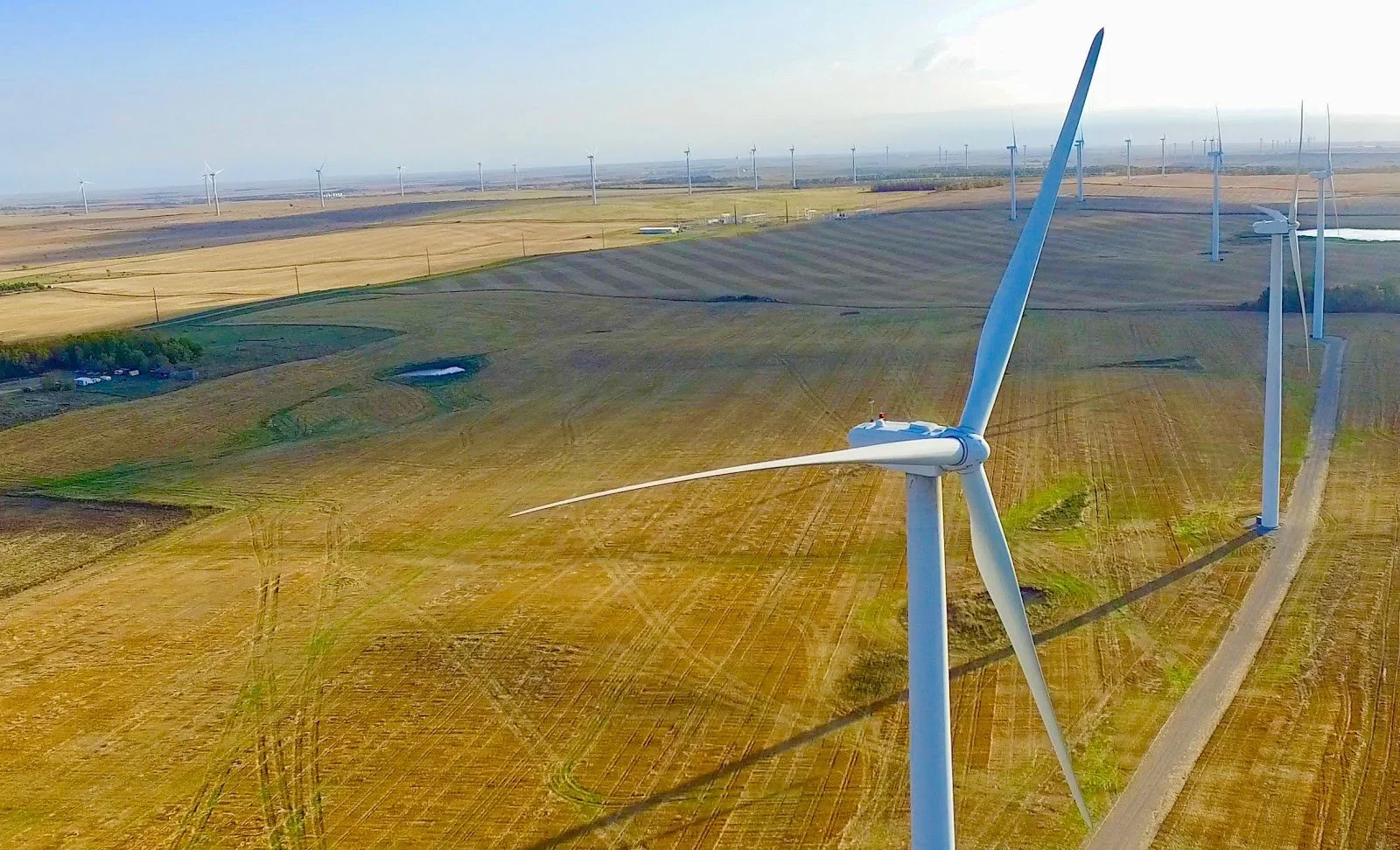
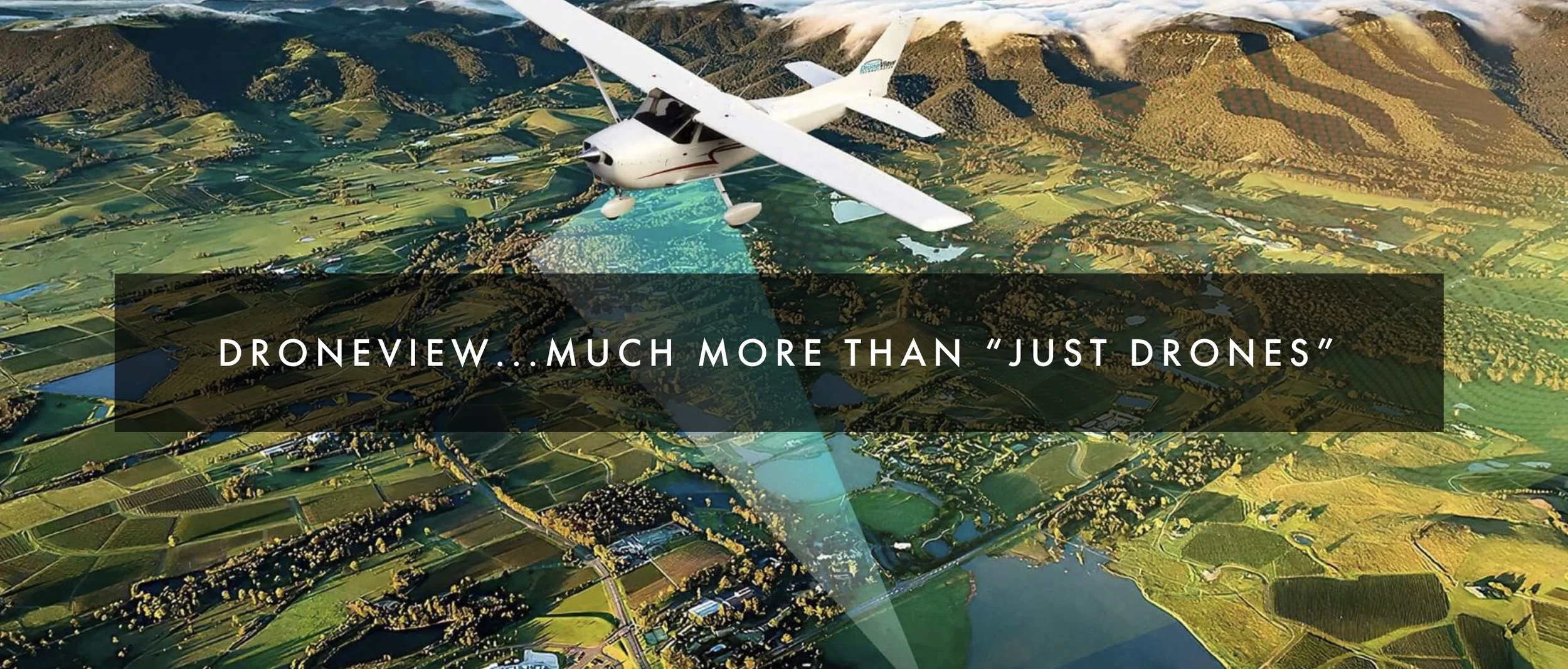
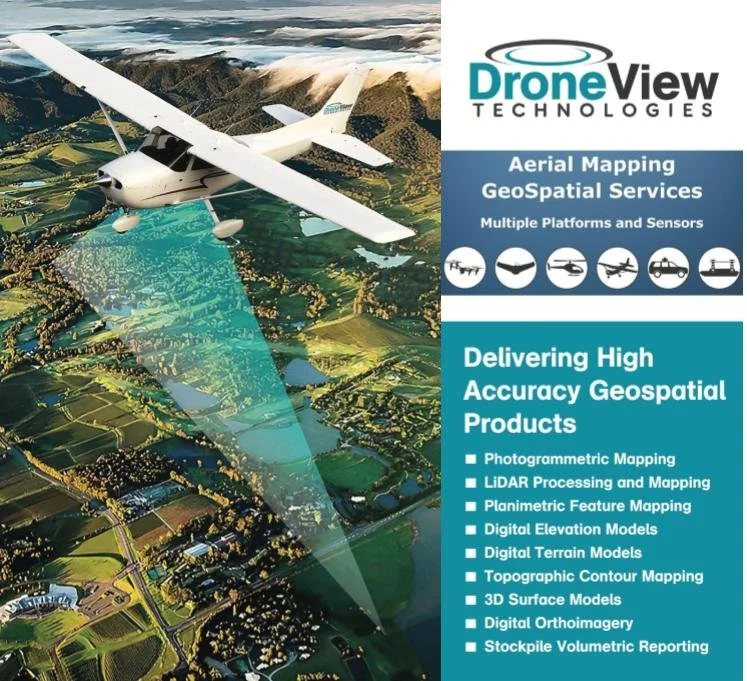
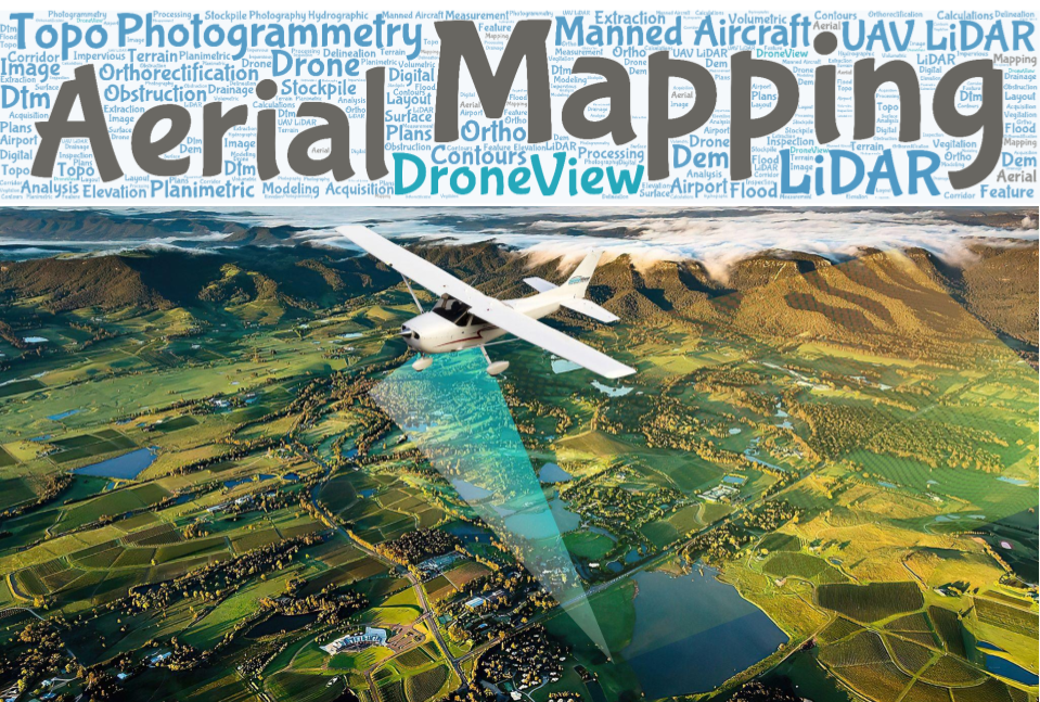
DroneView provides high accuracy mapping and geospatial services to customers throughout the United States.
In addition to our fleet of drones (imagery and LiDAR), we also utilize

  • manned aircraft (imagery and LiDAR); mobile LiDAR and bathymetric mapping systems

Jul 23, 2020
Project Spotlight: FAA approved Airport Layout Plan (ALP) & Airport Mapping
May 13, 2020
Project Spotlight: FAA approved Airport Layout Plan (ALP) & Airport Mapping
May 13, 2020
May 13, 2020
DroneView+Supporting+Surveyors.jpg
Feb 13, 2020
DroneView Supports Surveyors with Aerial Mapping and Geospatial Services
Feb 13, 2020
Feb 13, 2020
DroneView Technologies: Year in Review and Outlook for 2020
Jan 8, 2020
DroneView Technologies: Year in Review and Outlook for 2020
Jan 8, 2020
Jan 8, 2020
Stockpile+Image.jpg
Nov 5, 2019
Project Spotlight: Stockpile Inventory Measurement and Custom Reporting
Nov 5, 2019
Nov 5, 2019
electric+utility+lidar.jpg
Oct 24, 2019
Project Spotlight: Electric Utility Mapping + Inspection
Oct 24, 2019
Oct 24, 2019
DroneView+Profile+-+page+1.png
Oct 22, 2019
DroneView Technologies - Company Profile
Oct 22, 2019
Oct 22, 2019
Project+Spotlight+-+Solid+Waste+Landfill.jpg
Oct 2, 2019
Project Spotlight: Solid Waste Landfill
Oct 2, 2019
Oct 2, 2019
DroneView+Technologies+-+Davis+Aerospace+Technical+High+School+-+05-09-2019.jpg
May 10, 2019
Davis Aerospace Technical High Students Field Trip to DroneView Technologies
May 10, 2019
May 10, 2019
michael-singer-agg1-academy-session-2019.jpg
Feb 19, 2019
Considerations to make when integrating a drone into your operation
Feb 19, 2019
Feb 19, 2019
world+of+asphalt+2019.png
Feb 8, 2019
Drones: Realizing Real Value While Insuring Accuracy & Consistency
Feb 8, 2019
Feb 8, 2019
Manned++LiDAR+Acquisition+.jpg
Jan 8, 2019
DroneView Technologies: Year in Review and Outlook for 2019
Jan 8, 2019
Jan 8, 2019
Capture.JPG
Jan 2, 2019
Commercial UAV News: 2019 Predictions for the Commercial Drone Industry with Michael Singer
Jan 2, 2019
Jan 2, 2019
autonomous+driving.jpg
Oct 16, 2018
Precision Mapping - Critical for the Future of Autonomous Driving
Oct 16, 2018
Oct 16, 2018
Back to Previous page


866.235.9400

Michigan | Florida | texas | ohio | indiana | illinois | wisconsin

Copyright 2025 droneview technologies